
Death Valley National Park
Death Valley National Park lies just east of Highway 395 and the Eastern Sierra, but its famous core is farther than it looks. From Big Pine, Panamint Springs on the park's west edge is about two hours away, and Furnace Creek and Badwater Basin are closer to three hours. Eureka Dunes, on Big Pine Road, is the easy day trip.
If Badwater, Zabriskie Point, and the salt flats are the whole reason for your trip, sleep inside the park or in Lone Pine. If Death Valley is one day of a longer Eastern Sierra trip, we recommend Palisades Lodge in Big Pine, 15 miles south of Bishop on Highway 395, about a 15- to 20-minute drive.
What Is Death Valley?
Death Valley is the largest national park in the lower 48 states, about 3.4 million acres of desert basins, salt flats, dunes, and mountain ranges along the California and Nevada border. Badwater Basin, 282 feet below sea level, is the lowest point in North America. Telescope Peak, on the range above it, reaches 11,049 feet.
It is the hottest, driest, and lowest national park in the country. The highest air temperature on record, 134°F, was measured at Furnace Creek on July 10, 1913, and the valley averages less than two inches of rain a year.
Death Valley is the homeland of the Timbisha Shoshone, whose history here goes back more than 10,000 years. The tribe's village is at Furnace Creek, on land Congress placed in trust for the Timbisha in 2000. The English name came later, from emigrants who entered the valley around Christmas 1849; one of them reportedly said "Goodbye, Death Valley" as they finally climbed out. Borax mining followed in the 1880s, and the park itself was protected as a national monument in 1933 and became a national park in 1994.
How Far Is Death Valley From Big Pine?
There are two ways into Death Valley from Big Pine, and they lead to very different parts of the park.
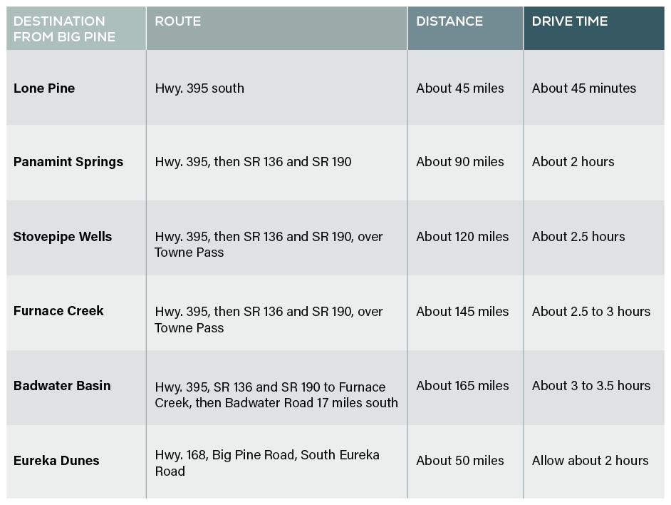
Distances are approximate, and drive times assume good conditions with no stops. The National Park Service puts Furnace Creek about one hour and 45 minutes from Lone Pine, so add the drive down Highway 395 from Big Pine.
The west entrance, through Lone Pine
This is the paved route and the right one for the classic sights. Drive south on Highway 395 past Manzanar National Historic Site to Lone Pine, then take SR 136 around the edge of Owens Lake to SR 190 and follow it east into the park.
Stop first at the Eastern Sierra Interagency Visitor Center, just south of Lone Pine at the junction of 395 and SR 136. Staffed by the National Park Service, the Forest Service, and the BLM, it provides current road and weather conditions and is open daily from 8:30 to 4:30.
From Lone Pine, it is 47 miles to Panamint Springs with no services in between. The road then climbs over Towne Pass, at nearly 5,000 feet, and drops all the way down to the valley floor near Stovepipe Wells. Use a low gear on the long descents. The park service names vehicle accidents as the leading cause of death in Death Valley.
The back door, Big Pine Road
Big Pine Road, also called Death Valley Road, leaves Highway 168 just outside Big Pine, on the same road that leads to the Ancient Bristlecone Pine Forest, and climbs over the Inyo Mountains into Eureka Valley, at the far north end of the park. It is paved for much of the way, then becomes graded dirt. There are no services of any kind.
This is the road to Eureka Dunes, and it works well for that trip. Continuing through to Ubehebe Crater and the rest of the park is a different matter. It is a long, slow drive on dirt with stretches of washboard, and recent storms have left washouts that call for some ground clearance. We would not use it as a shortcut to Furnace Creek.
A third route runs east on Highway 168 into Nevada and enters the park from Beatty. It only makes sense as part of a Nevada road trip.
Can You Visit Death Valley as a Day Trip From Big Pine?
Yes, for some of it.
Eureka Dunes is a genuine day trip from Big Pine, and it is the part of Death Valley closest to Highway 395. More on that below.
The west side of the park makes for a long but doable day. Father Crowley Vista, Panamint Springs, the Mesquite Flat Sand Dunes, and Mosaic Canyon are all within about two to two and a half hours of Big Pine, and you can see two or three of them and be back in Big Pine by evening.
Badwater, Zabriskie Point, and Artists Drive are not a day trip from Big Pine. That is close to six hours of driving for a few hours on the ground. For the park's classic core, spend at least one night inside it or in Lone Pine.
What to See on the West Side of Death Valley
The west side is the first part of Death Valley you reach from Highway 395, and the quietest.
Father Crowley Vista and Rainbow Canyon
Father Crowley Vista sits on SR 190 just inside the park's western boundary, above the dark, layered walls of Rainbow Canyon. The main overlook is listed by the park service as wheelchair accessible, and a short unpaved walk of about a quarter mile leads to Padre Point for a wider view. Military jets used to fly training runs through the canyon below, which made it famous with photographers. Those flights ended after a crash in 2019.
Panamint Springs and Darwin Falls
Panamint Springs is the small resort at the western edge of the park, with fuel, food, and lodging. Darwin Falls, a spring-fed waterfall that runs year-round in a nearby canyon, is normally a short hike from a dirt road. As of October 2026, that road is washed out and expected to stay closed until about summer 2027. You can still park on the shoulder of SR 190 and walk in, but that makes it about a seven-mile round trip.
Mesquite Flat Sand Dunes and Mosaic Canyon
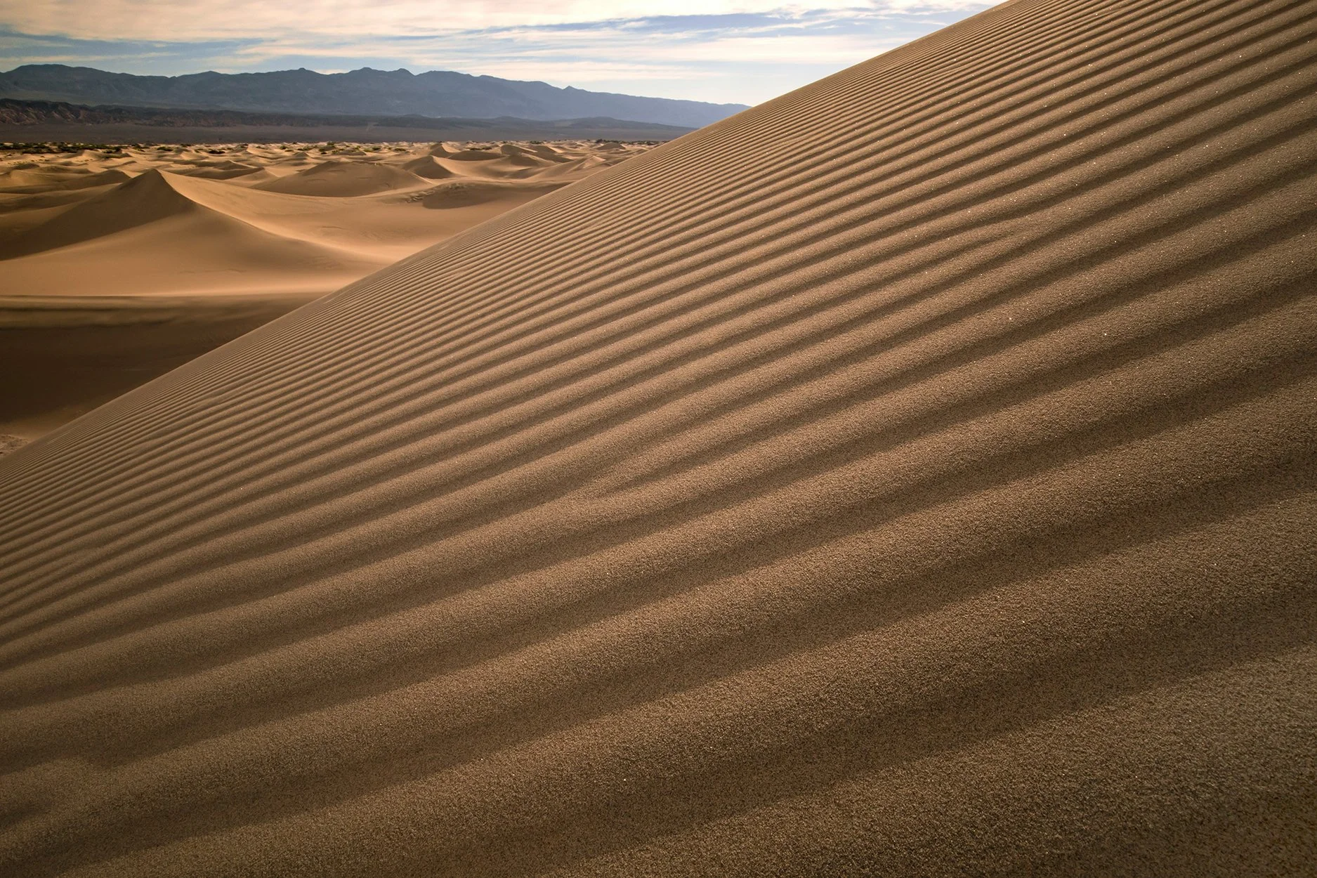
Near Stovepipe Wells, about two and a half hours from Big Pine, the Mesquite Flat dunes rise right beside the highway. There is no trail; walk out as far as you like. A round trip of about two miles takes most people an hour and a half. Early morning and late afternoon light shows the ridges best, and in the warmer months the sand gets hot quickly.
Mosaic Canyon is reached by a 2.3-mile unpaved road from Stovepipe Wells. The first narrows, polished smooth marble, begin less than a quarter mile from the trailhead, so even a short walk is worth it. The road is usually fine in a regular car but not recommended for buses or large RVs.
Wildrose Charcoal Kilns and Aguereberry Point
For a quieter detour, the Wildrose Charcoal Kilns are ten stone beehive kilns in Wildrose Canyon, finished in 1877 to make charcoal for silver mines in the nearby hills. The last two miles are gravel and passable for most vehicles, and Lower Wildrose Road, reopened in June 2026, is limited to vehicles under 25 feet. Allow at least an hour and a half. Nearby Aguereberry Point looks out from about 1,000 feet higher than Dante's View, on a gravel road whose final climb may need higher clearance.
The Classic Core: Furnace Creek and Badwater
This is the Death Valley most people picture, and it deserves a night in the park.
Badwater Basin is 17 miles south of Furnace Creek. A ramp and boardwalk lead onto the salt flat, and a one-mile round trip takes you to the edge of the white crust. The hexagonal salt patterns that appear in photographs start farther out, about a mile and a half to two miles round trip.
Zabriskie Point is about 15 minutes from Furnace Creek on SR 190, at the top of a short paved path. It’s best at sunrise, when the eroded badlands below light up first.
Golden Canyon starts two miles down Badwater Road and is one of the park's best short hikes in the cooler months. Loops run from an hour and a half to more than four hours.
Artists Drive is a nine-mile one-way paved loop past hillsides streaked with color from oxidized minerals. Late afternoon light brings the colors out. Vehicles must be 25 feet or shorter.
Dante's View, about 45 minutes from Furnace Creek, looks straight down on Badwater from more than 5,500 feet above it.
Harmony Borax Works, a mile from Furnace Creek, is where the famous 20-mule teams hauled borax about 165 miles across the desert to the railroad at Mojave in the 1880s. A short, easy loop of under half a mile passes the ruins.
Salt Creek reopened in February 2026 after flood damage. Its half-mile boardwalk follows a spring-fed creek, saltier than the ocean in places, where tiny pupfish spawn in the cooler months.
Several of these stops work for visitors with limited mobility. Badwater has a ramp and boardwalk, Salt Creek's boardwalk is wheelchair accessible, and the park service lists the viewpoints at Zabriskie Point, Dante's View, and Father Crowley Vista as accessible.
Eureka Dunes: Death Valley's Big Pine Back Door
Eureka Dunes is the part of Death Valley that belongs to Big Pine. It is about 50 miles from town on Big Pine Road, and the turnoff is a few minutes from the lodge.
The dunes rise more than 680 feet above the floor of Eureka Valley, the tallest in California, against the dark wall of the Last Chance Range. When sand slides down the steepest faces, it can make a low booming sound, which is why these are sometimes called singing dunes. Sandboarding is not allowed.
Getting there means Highway 168 east, Big Pine Road north over the Inyo Mountains and down into Eureka Valley, then South Eureka Road to the dunes. Big Pine Road is paved for much of the way. South Eureka Road is not. After storm damage in 2023, the park service describes parts of it as narrow and unstable, with deep sand that can trap vehicles, and it has proposed repairs that have not yet begun. A high-clearance vehicle is the safe choice, and it is worth checking current conditions with the park before you go.
No services are available anywhere on the route. The small campground at the dunes has a few sites with tables and a vault toilet, and no water. Nights in Eureka Valley can drop well below freezing from late fall through winter.
Carry everything you need from Big Pine. Hi-Country Market, across the street from Palisades, is the best gas and water stop before Death Valley: fill the tank, buy ice and more water than you think you will need, and you are on Highway 168 in a few minutes.
What Is Closed in Death Valley Right Now?
Flooding in 2022, Hurricane Hilary in 2023, and storms in 2025 damaged roads across the park, and repairs are still underway. As of October 2026, according to the National Park Service:
Scotty's Castle is closed for flood recovery, along with Bonnie Clare Road. Ticketed exterior tours of the grounds run on most weekends from October to mid-April through the Death Valley Natural History Association. The earliest full reopening is November 2028.
Titus Canyon is closed. The one-way section through the canyon is under repair until about May 2027, and the short two-way section at the western end closes from late October through December.
Darwin Falls Road is closed, likely until summer 2027. Walking in from SR 190 is about seven miles round trip.
Salt Creek, Artists Drive, Ubehebe Crater Road, and Lower Wildrose have all reopened since late 2025.
Conditions change quickly here. Check the park service's current conditions page the day before you go.
When Is the Best Time to Visit Death Valley?
Mid-October through April. Days are mild, the light is long and low, and most trails are comfortable.
Summer is a different place. From June through September, average highs are over 110°F, and July averages 116°F. The park service advises against hiking at low elevations after 10 a.m. in summer. If you go then, see the valley floor at sunrise and spend the afternoon at higher elevations or in the car.
Wildflowers bloom at low elevations from late March to early April, moving higher through May and into June in the mountains. Spring 2026 brought the strongest bloom in a decade after heavy fall rains. How much color any year brings depends on that winter's rain, so check the park's reports in March.
Winter is the best season on the valley floor, but Big Pine Road climbs to more than 7,000 feet and can see snow and ice.
Death Valley is also a Gold Tier International Dark Sky Park, one of the darkest places in the country to see the night sky. Our Eastern Sierra stargazing guide covers dark-sky viewing closer to home.
What Should You Know Before You Go?
The entrance fee is $30 per vehicle and covers seven days. The park takes card or digital payment only. Pay online in advance at Recreation.gov or at the Furnace Creek Visitor Center, the Stovepipe Wells Ranger Station, or Zabriskie Point.
Gas inside the park is available at Panamint Springs, Stovepipe Wells, and Furnace Creek, and it costs more than in the Owens Valley. Stovepipe Wells sells regular unleaded only and has no diesel. Fill up in Big Pine or Lone Pine.
Carry at least a gallon of water per person per day, more in warm weather. You can refill at Furnace Creek, Stovepipe Wells, and Panamint Springs.
Most of the park has no cell service, and GPS directions can be unreliable on remote roads. Download offline maps and the park map before you leave, and carry a paper road map.
Flash floods are most likely during late-summer thunderstorms. Stay out of canyons when rain is in the forecast, even if the sky above you is clear.
Fees, closures, and road conditions change often. Confirm details with the National Park Service before your trip.
Where Should You Stay to Visit Death Valley?
Where you stay depends on which Death Valley you want to see.
Choose a stay inside the park, at Furnace Creek, Stovepipe Wells, or Panamint Springs, when Badwater, sunrise at Zabriskie Point, and the classic core are the point of the trip.
Choose Lone Pine when you want the closest Highway 395 town to the west entrance, with the Alabama Hills just west of town.
Choose Big Pine when Eureka Dunes is the goal, or when Death Valley is one day of a longer Eastern Sierra trip that also includes the Ancient Bristlecone Pine Forest and Big Pine Lakes. Our Highway 395 road trip guide shows how the pieces fit together.
For that kind of trip, we recommend Palisades Lodge. Every unit is a full apartment with a kitchen, which makes a day with no services far easier: pack the cooler the night before, fill up at Hi-Country across the street in the morning, and come back to a real meal and room to spread out. Weekly and monthly rates are available for longer stays.
Palisades Lodge is 15 miles south of Bishop on Highway 395, minutes from the Big Pine Road turnoff and about two hours from the park's western edge.
Explore the available apartments and book direct.
Frequently Asked Questions
-
Panamint Springs, at the western edge of Death Valley, is about 90 miles and two hours from Big Pine by way of Lone Pine, SR 136 and SR 190. Furnace Creek is about 145 miles and two and a half to three hours. Eureka Dunes, in the north of the park, is about 50 miles from Big Pine on Big Pine Road.
-
Partly. Eureka Dunes is a realistic day trip from Big Pine, and the west side of the park, including Father Crowley Vista and the Mesquite Flat Sand Dunes, makes a long but workable day. Badwater Basin and Zabriskie Point are too far for a day trip and are best seen with a night in the park or in Lone Pine.
-
The main western entrance is reached from Lone Pine on SR 136 and SR 190, which reaches Panamint Springs about 47 miles from Lone Pine. From Big Pine, Big Pine Road enters the far north of the park on a partly unpaved route used mainly to reach Eureka Dunes.
-
Fill up in Big Pine or Lone Pine. Lone Pine to Panamint Springs is 47 miles with no services. Inside the park, gas is available at Panamint Springs, Stovepipe Wells and Furnace Creek, and Stovepipe Wells has no diesel. Big Pine Road has no services at all.
-
A high-clearance vehicle is the safe choice. Big Pine Road is paved for much of the way, but South Eureka Road, the last stretch to the dunes, is unpaved, and the National Park Service describes parts of it as narrow and unstable with deep sand. Check current conditions with the park before driving it.
-
No. As of October 2026, Scotty's Castle and Bonnie Clare Road are closed for flood recovery. Ticketed exterior tours of the grounds run on most weekends from October to mid-April through the Death Valley Natural History Association, and the earliest full reopening is November 2028.
-
The entrance fee is $30 per private vehicle and is valid for seven days. A motorcycle is $25 and a visitor on foot or bicycle is $15. Payment is by card or digital payment only, online at Recreation.gov or at park visitor centers and fee stations.
-
Mid-October through April is the best time to visit Death Valley. Summer highs average over 110°F from June through September, and the National Park Service advises against low-elevation hiking after 10 a.m. in summer. Wildflowers bloom at low elevations from late March to early April in wetter years.
-
There is no cell service in most of Death Valley National Park, and GPS directions can be unreliable on remote roads. Download offline maps and carry a paper road map before leaving Big Pine or Lone Pine. Paid Wi-Fi is available at the Ranch at Death Valley in Furnace Creek.
AT A GLANCE
Where is It: East of the Owens Valley, entered from Lone Pine on SR 136 and SR 190, or from Big Pine on Big Pine Road
From Big Pine: about 90 miles to Panamint Springs, about 145 miles to Furnace Creek
Entrance fee: $30 per vehicle for seven days, card or digital payment only
Best Season: mid-October through April
Last Gas: Big Pine or Lone Pine, then Panamint Springs, Stovepipe Wells or Furnace Creek inside the park
Phones: no cell service in most of the park, so download maps before you leave
Conditions checked: October 2026, National Park Service current conditions
