
Highway 395 Road Trip: The Eastern Sierra Guide from Death Valley to Yosemite
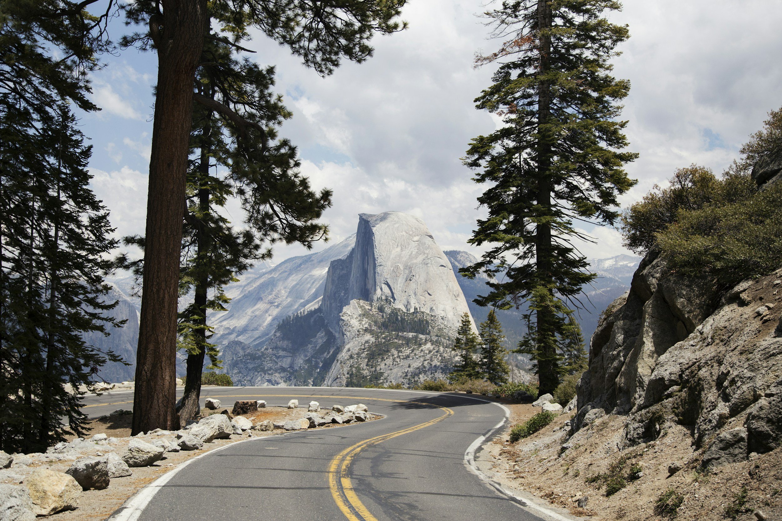
A view of Half Dome (Yosemite National Park) from Tioga Rd.
Highway 395 runs up the east side of the Sierra Nevada, linking Death Valley and Yosemite through the Eastern Sierra. It is one of the best road trips in California, and Big Pine sits right in the middle of it. This guide walks the whole route: how many days to plan, what to stop for, the Tioga Pass question that makes or breaks the loop, and where to base yourself.
The Route in Brief
The classic version runs south to north. Start in Death Valley, climb out to Highway 395 near Lone Pine, and follow the road up the Owens Valley past Big Pine, Bishop, and Mammoth Lakes to Mono Lake. From there, if Tioga Pass is open, Highway 120 crosses the mountains into Yosemite. Big Pine sits near the center of that line, which makes it an easy place to sleep while you explore in both directions.
How Many Days Do You Need?
The honest answer is more than most people plan. You can drive 395 end-to-end in a day, but you will spend it in the car and see almost none of it. Give it a few days, and base in one spot so you are not packing up every morning.
Two days, a taste. Base in Big Pine. Spend one day on the southern stops, Alabama Hills and Manzanar, and one day closer to home on either the Ancient Bristlecones or the Big Pine Lakes trail. The lakes are a full-day hike, so pick one or the other. Good if you are passing through.
Four days, the classic run. Add Bishop and Mammoth Lakes to the north and Mono Lake at the top, plus a full day for either Death Valley or the drive over Tioga into Yosemite.
Five to seven days, the full corridor. Death Valley on one end, Yosemite on the other, the Eastern Sierra in between, and enough time to slow down. This is the trip the road deserves.
From Big Pine, most of these stops are short hops: about 15 minutes to Bishop, an hour to Mammoth, 45 minutes up to the Bristlecones, a little over two hours to Death Valley, and about an hour and a half to the Tioga Pass gate, with Yosemite Valley itself a bit further on. Full drive times are in the getting-around section below.
Why Base in Big Pine?
Big Pine works because it is central. It sits on Highway 395 about 15 miles south of Bishop, roughly halfway between the Death Valley turnoff to the south and the Mono Lake and Tioga gateway to the north. You can reach either end in about two hours and most of the stops in between in under an hour, without changing towns every night.
That central spot is the whole argument. The bigger resort towns pull you to one end of the route or price up in season. From Big Pine you drive out, see what you came for, and come back to the same bed.
Palisades Lodge of Big Pine has full apartments with kitchens, so you can cook after a long day instead of chasing a small-town kitchen that closes at nine. Contactless check-in makes a late arrival off the highway easy, and weekly and monthly rates work for longer Eastern Sierra trips. Hi-Country Market across the street is the practical stop for gas, water, and supplies before any leg into the high country.
The Stops, South to North
Here is what is worth pulling over for, in the order you will hit them driving north.
Alabama Hills and Lone Pine. Just west of Lone Pine, the Alabama Hills are a field of rounded granite that has stood in for the Old West and other planets in hundreds of films. The Mobius Arch frames Mt. Whitney through a short loop off Movie Road, and sunrise and sunset are the best light. Some of the deeper roads want a high-clearance vehicle, so do not follow the map blindly onto the dirt.
Manzanar. A few miles north, Manzanar National Historic Site marks where the U.S. government incarcerated more than 10,000 Japanese Americans during World War II. The reconstructed barracks and the driving tour are worth the hour, and admission is free.
Big Pine, the Bristlecones, and Big Pine Lakes. Big Pine is the quiet center of the route, and it holds two of the best things on it. To the east, up Highway 168 and White Mountain Road, the Ancient Bristlecone Pine Forest holds some of the oldest living trees on earth, more than 4,000 years old. To the west, up Glacier Lodge Road, the Big Pine Lakes trail climbs to a string of turquoise glacial lakes under Temple Crag and the Palisade Glacier, the southernmost glacier in the United States. Each is a full day from town, so plan on just one on a short trip. Both roads are seasonal: the Bristlecone road is usually open only from about mid-May into fall, and Glacier Lodge Road closes for snow, with a gate near Glacier Lodge shutting the upper road in the snowy months. Check conditions before you drive up.
Bishop. Bishop is the biggest town on the route and the place to resupply. Erick Schat’s Bakery is the local institution for sheepherder bread, gas is cheapest here, and it has the fullest services and the only fast chargers for miles. It is a good midday stop even when you are sleeping in Big Pine.
Mammoth Lakes. Mammoth is the resort town, higher and cooler, with alpine lakes, Devils Postpile, and the summer gondola. It is worth a day if you have one, though it draws crowds and prices in season.
Mono Lake. At the north end, Mono Lake is a strange, ancient saline lake dotted with tufa towers, calcium spires that rise out of the water. The South Tufa area at sunrise or sunset is the shot, and it sits right below the Tioga Pass road into Yosemite.
Will Tioga Pass Be Open?
This is the question that makes or breaks the loop. Tioga Pass, Highway 120 over the mountains into Yosemite, is the only convenient crossing that links the 395 corridor to Yosemite Valley. It climbs to nearly 10,000 feet and closes with the snow.
It is reliably open from roughly June through September or October, and reliably closed in winter. The shoulders are a gamble. It has opened as early as April and as late as July, and closed as early as mid-October, so do not plan around a fixed date. Check the live status before you build the Yosemite leg.
If Tioga is closed, you cannot cross the mountains here. The detour to Yosemite Valley runs south and around through Bakersfield and Fresno, roughly 450 miles and nine hours. So when the pass is closed, treat Death Valley and the Eastern Sierra as the trip, and save Yosemite for a separate run in from the west on Highway 140 or 41, which stay open year-round.
Getting Around: Gas, Charging, and Cell Service
The Eastern Sierra is rural, and the gaps between services are real. A little planning keeps the trip smooth.
Gas. Fill up in the towns, not between them. Bishop is the cheapest, and every corridor town, including Big Pine, has a station. Avoid topping off in Lee Vining or inside Death Valley, where prices run high.
EV charging. Fast charging is thin and concentrated in the bigger towns, with Bishop the main hub on the route. Smaller stops may only have slower charging, and there is none on the Tioga Pass crossing itself, so cross the mountains on a full charge. New stations are being added along 395, and the climbs eat range faster than the miles suggest, so check a charging app for current fast chargers before you rely on one.
Cell service. Coverage drops out fast off the highway, including at the Bristlecones and much of Death Valley. Download your maps before you leave town, and do not count on your phone in the backcountry. Verizon and AT&T hold up better than T-Mobile out here.
Road status. Mountain roads close due to snow and rockfalls with little notice. Check Caltrans QuickMap or call 800-427-7623 before any high-country drive, especially Tioga, the Bristlecone Road, and Glacier Lodge Road, during the shoulder seasons.
When to Go
Late spring through early fall is the window when the whole route works, because that is when Tioga Pass is open. Each season has a trade-off.
Summer. The high country is open, and the lakes are at their best, but Death Valley is dangerously hot, often 110 to 120 degrees, and the towns are busiest. Do desert stops early in the morning.
Fall. The best all-around time. The aspens turn, Death Valley cools off, and the crowds thin. Fall color runs from late September into late October and moves by elevation, so start high in canyons like Bishop Creek and Rock Creek and work downhill as the weeks pass.
Winter. Tioga closes, so the Yosemite loop is off, but Highway 395 itself stays open, and the valley is quiet and clear. Carry chains, since chain controls can be in effect on mountain roads even with all-wheel drive.
Altitude, the Smart Way
The Eastern Sierra swings from below sea level in Death Valley to trailheads above 8,000 feet, sometimes in the same day. That is a lot of elevation to take on fast.
The move experienced travelers use is to sleep low and hike high. Base in a valley town like Big Pine at about 4,000 feet, then drive up for the day and come back down to sleep. Before a big climb, give yourself a day first and drink more water than you think you need. Easy walks like Lone Pine Lake or the lakes at Rock Creek help your body adjust before anything harder.
Camping Along the Route
If you would rather camp, the corridor is full of it, from the Alabama Hills to the Forest Service campgrounds up Bishop Creek and Rock Creek to the Mammoth Lakes basin. Many are first-come, and the rest book out months in advance in summer, so reserve early or have a backup plan. A town base is the easier option when you want a shower and a kitchen between nights out.
Eastern Sierra Hot Springs
The Eastern Sierra also has natural hot springs, mostly around Mammoth and Benton. They are worth seeking out, but many sit on sensitive or private land and get crowded, so look up current access and etiquette before you go, and pack out everything you bring in.
Where to Eat Along the Way
Small-town kitchens close early out here, often by nine, so plan meals around the drive. A few local institutions are worth timing a stop around: Copper Top BBQ in Big Pine, the local barbecue favorite for tri-tip and ribs; Erick Schat’s Bakery in Bishop for sheepherder bread; the Whoa Nellie Deli at the Tioga Gas Mart in Lee Vining; and the Alabama Hills Cafe in Lone Pine. Having a kitchen in your place takes the pressure off on nights when everything is closed.
Where to Stay on a Highway 395 Road Trip
Pick one central base and drive from it, rather than moving to a new place every night. Big Pine is the central town on the route, keeping your daily drives short in both directions.
Palisades Lodge of Big Pine has full apartments with kitchens, contactless check-in for late arrivals off the highway, free parking, and quiet nights, right on Highway 395. Weekly and monthly rates work for longer trips through the Eastern Sierra. Check Tioga Pass before you count on the Yosemite loop, give the route the days it deserves, and book direct for the best rate.
Frequently Asked Questions
-
Four to five days is the minimum to do the Death Valley to Yosemite corridor without rushing, and five to seven days does it well. Two days work for a taste if you base in one town.
-
A central base keeps your daily drives short. Big Pine sits midway between the Death Valley turnoff and the Yosemite gateway, with full apartments and kitchens at Palisades Lodge of Big Pine.
-
It is reliably open roughly from June through September or October and closed in winter, with unpredictable shoulder seasons. It climbs to nearly 10,000 feet and closes for snow, so check the live status before planning the Yosemite leg.
-
Yes, when Tioga Pass (Highway 120) is open, it is about a half day from the Eastern Sierra. If the pass is closed, the detour is around 450 miles, so it is better to save Yosemite for a separate trip in from the west.
-
Late spring through early fall, when Tioga is open. Fall is the sweet spot for aspen color and cooler Death Valley; summer is hot in the desert; winter closes the Yosemite crossing.
-
Gas is in every town and is cheapest in Bishop. Fast EV charging is concentrated in the larger towns, with Bishop as the main hub and none on the Tioga Pass itself, so plan your stops, cross the pass on a full charge, and check a charging app for current fast-charger locations.
AT A GLANCE
Route: Death Valley to Yosemite up Highway 395, through the Eastern Sierra
Best base: Big Pine, California, the central town on the route
Time needed: 2 days for a taste, 4 for the classic run, 5 to 7 for the full corridor
Best seasons: late spring through early fall, and fall for the aspen color
The catch: Tioga Pass into Yosemite is closed by snow much of the year, so check it before you plan the loop
Don’t miss: Alabama Hills, the Ancient Bristlecones, Big Pine Lakes, Mono Lake
Watch for: long gaps between gas, thin cell service, and big elevation swings
