Big Pine Lakes Trail Guide
The Big Pine Lakes Trail climbs from the end of Glacier Lodge Road into the John Muir Wilderness, reaching a chain of seven turquoise alpine lakes fed by the Palisade Glacier. The trailhead sits 10.7 miles west of Big Pine, California. No permit is required for day hikes. The trail is rated hard and ranks among the most popular Eastern Sierra hikes, with a roughly 15-mile round trip and more than 3,000 feet of elevation gain.
How to Get to the Big Pine Lakes Trailhead
The Big Pine Lakes trailhead is at the end of Glacier Lodge Road, 10.7 miles west of the town of Big Pine. From Highway 395, turn west onto Crocker Avenue, which becomes Glacier Lodge Road, and follow it to the end. Day hikers park at the day-use lot at the end of the road. Overnight hikers use the designated overnight lot 0.4 miles before the trailhead.
Both lots fill by 7 AM on summer weekends. If you are driving up the morning of your hike, plan to be on the road well before sunrise. Palisades Lodge of Big Pine sits 10.7 miles from the trailhead, about a 26-minute drive. From Bishop, the trailhead is 25 miles away and roughly 40 minutes away, which adds nearly half an hour to your morning on a day when minutes at the parking lot decide whether you hike or wait.
What to Expect on the Trail
The Big Pine Creek North Fork Trail starts steep and exposed. The first two miles climb open sagebrush slopes with no shade, switchbacking up the hillside above the creek. Most hikers feel the altitude here, especially in the warm hours after 9 AM.
The first one to two miles are also a good option for an easier, scenic stroll if you are not looking to commit to the full ascent. The early stretch offers forested views of the creek and a taste of the canyon without the steep climb that follows.
Around mile 1.6, the trail crosses a footbridge and enters Jeffrey pine and aspen shade. Second Falls drops to your left, a worthwhile pause. The grade eases through the forest until you reach Lon Chaney's Cabin near the halfway point. The cabin was built in 1929 by the silent-film actor as a private retreat and is now a Forest Service historic site. It is the natural rest stop and water break before the final push.
The last two miles climb again through manzanita, switchbacks, and wildflower meadows. The trail levels as you approach First Lake, the first of the chain.
For a shorter, completely different trip, the South Fork Trail branches off near the Big Pine Creek trailhead and leads to Brainard Lake. It is generally considered less challenging than the steep North Fork route to the numbered lakes and is worth considering for hikers who want a lighter day in the same canyon.
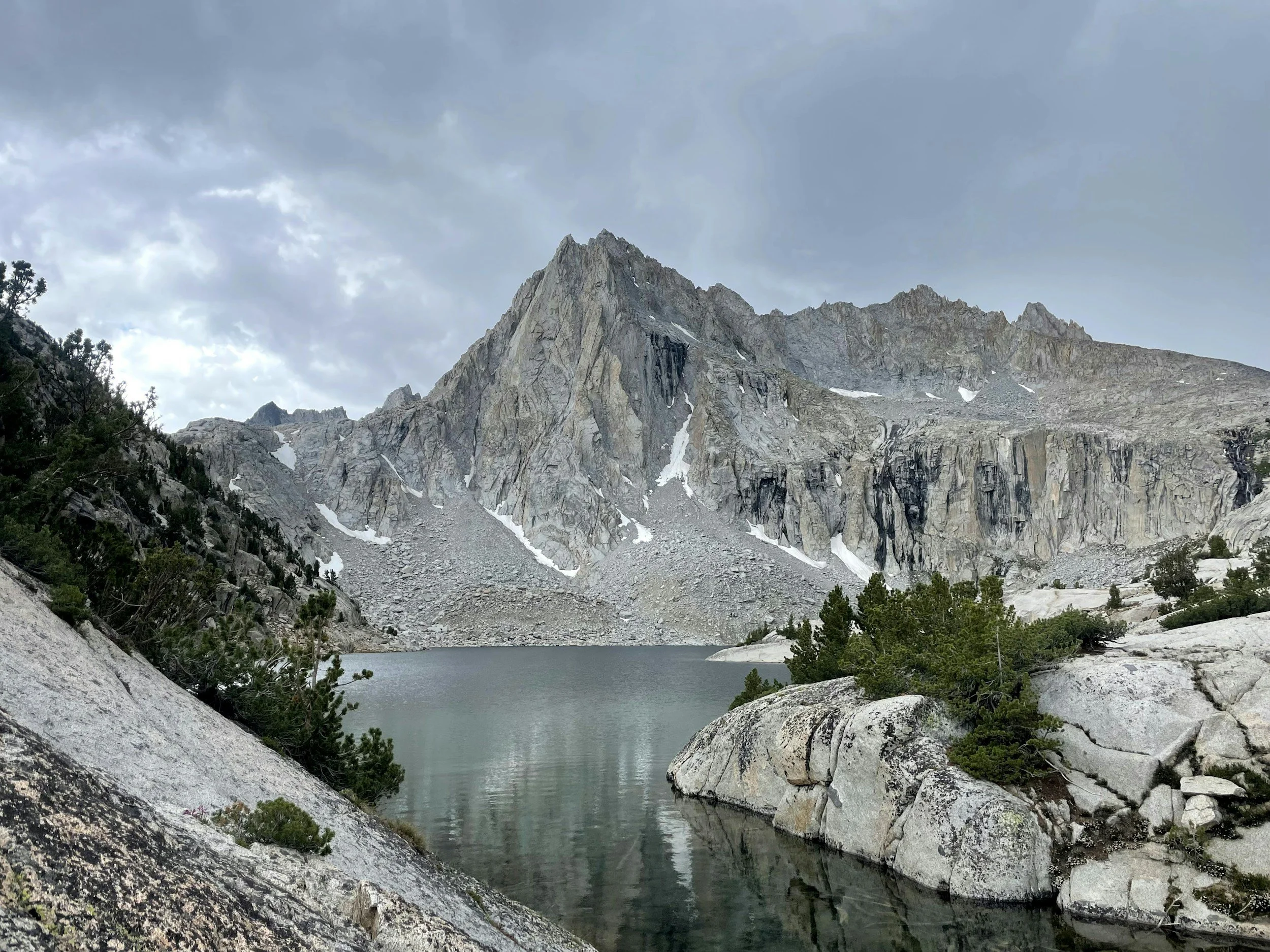
The Lakes
The signature views begin at First Lake. The water is an unmistakable opaque turquoise, the result of glacial flour, fine rock particles ground by the Palisade Glacier and held in suspension. Second Lake is the most photographed of the chain, with Temple Crag looming over the far shore. Third Lake adds another quarter mile and another angle on Temple Crag and the Palisade Group.
Most day hikers turn around at Second or Third Lake. Hikers with more time and energy continue to Fourth, Fifth, Sixth, and Seventh Lakes, set higher into the cirque. A spur trail leads to Black Lake, often quieter than the main chain. Beyond the lakes, Sam Mack Meadow opens into terrain that hikers regularly compare to the Swiss Alps.
What You Need to Know Before You Go
The hiking season runs late June through early October, when the trail is reliably snow-free, and the lakes are at peak color. Snow can linger into July in heavy-snowpack years. Check current conditions on AllTrails and the USFS Big Pine Creek North Fork Trail page before you go.
Altitude is the single biggest factor most hikers underestimate. The trailhead is already at 7,700 feet, and the lakes sit above 10,000 feet. Hydrate aggressively, eat consistently, and consider arriving the day before to acclimate.
Other essentials: filter or treat any water you collect from creeks and lakes. Pack out all trash and used toilet paper. Cell service is limited at the trailhead and nonexistent past the first mile. Campfires are prohibited at most lake elevations. Bear canisters are required for all overnight stays.
Permits
Day hikes do not require a permit. Big Pine Lakes backpacking trips require a John Muir Wilderness permit, with a daily quota of 25 overnight visitors from May 1 through November 1.
Permits are issued through recreation.gov. Sixty percent of permits are released six months in advance, and the remaining forty percent are released two weeks before the entry date. Summer weekends sell out within minutes of release. If you miss the six-month window, set a calendar reminder for the two-week release.
Where to Stay Near the Big Pine Lakes Trailhead
Hikers have three practical options for sleeping near the trailhead.
Camp at the trailhead. Big Pine Creek Campground, Upper Sage Flat, and Sage Flat all sit along Glacier Lodge Road within a few miles of the trailhead. These are the closest options and the choice for hikers who want to be steps from the trail.
Stay in Big Pine. Palisades Lodge of Big Pine is 10.7 miles from the trailhead, a 26-minute drive. The lodge offers full apartments with kitchens, which is useful for cooking an early breakfast on trail day and a hot dinner when you stumble back at sunset. A walk-in shower after a 15-mile alpine day matters more than most hikers admit.
Stay in Bishop. Bishop is 25 miles from the trailhead, about 40 minutes by car, with more dining and services than Big Pine. The trade-off is a longer pre-dawn drive on summer weekends when the parking lot fills early.
Frequently Asked Questions
-
There are seven numbered lakes along the main Big Pine Lakes Trail, named First Lake through Seventh Lake. A short spur trail also leads to Black Lake, and Summit Lake sits at the highest point of the chain. Most day hikers visit First, Second, and Third Lake.
-
The full Big Pine Lakes Trail is approximately 15 miles round-trip if you visit all seven lakes. Most day hikers turn around at First or Second Lake, which is roughly 10 to 11 miles round-trip from the trailhead at the end of Glacier Lodge Road.
-
No permit is required for day hikes on the Big Pine Lakes Trail. Overnight backpackers do need a John Muir Wilderness permit, available through recreation.gov, with a daily quota of 25 overnight visitors from May through November.
-
AllTrails rates the Big Pine Lakes hike as hard. The trail climbs more than 3,000 feet of elevation gain over roughly 7.5 miles one way, with the trailhead starting at 7,700 feet. Altitude, distance, and exposed early-mile climbs make it a strenuous day hike.
-
The best time to hike Big Pine Lakes is late June through early October, when the trail is snow-free and the alpine lakes are at peak turquoise color. July and August are the most reliable months. Snow can linger into July in heavy-snow years.
-
The Big Pine Lakes trailhead is at the end of Glacier Lodge Road in Inyo National Forest, 10.7 miles west of the town of Big Pine, California. From Highway 395 in Big Pine, turn west onto Crocker Avenue and follow Glacier Lodge Road to the end.
-
Yes, you can swim in Big Pine Lakes, though the water is glacier-fed and stays cold even in midsummer. Most swimmers visit First, Second, or Third Lake, where the shoreline is most accessible. Swim at your own risk; there are no lifeguards or facilities.
Plan Your Hike from Big Pine
The closest full-apartment lodging to the Big Pine Lakes trailhead is 10.7 miles down Glacier Lodge Road. Cook your trail breakfast in your own kitchen, leave by 5:30 AM, and beat the parking-lot rush.
AT A GLANCE
Distance: ~15 miles round trip for all seven lakes; ~10 miles round trip to First and Second Lake
Elevation gain: ~2,300 feet to First Lake; ~3,400 feet to Third Lake
Starting elevation: 7,700 feet
Difficulty: Hard
Time: 8 to 9.5 hours for the full trail; 3.5 to 4.5 hours to First Lake
Best season: Late June through early October
Permit: Not required for day hikes; required for overnight (recreation.gov)
Dogs: Allowed
Trailhead: End of Glacier Lodge Road, John Muir Wilderness, Inyo National Forest